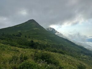
On August 8, I was able to go on an amazing hike along Potter Ridge with alaskatim, glenn.fish, Ladybug Kids, rb127126, and Shrike841. A few weeks prior, I had heard murmurs that a hike was being planned and that I should get myself on the invite list. For those unfamiliar with Potter Ridge, it is roughly L-shaped and consists of Caballo Blanco, Ruby Peak (aka McHugh Peak-West), McHugh Peak, Houdini Hill, and Grandview Peak.
We met at the agreed-upon early hour of 08:00 at Storck Park and soon enough started up the trailhead on Potter Heights Dr. The beginning of the trail was a bit tricky with head-high grass, which eventually transitioned to trees, including the occasional wall of alders. Our first cache was one of Ladybug Kids’ placements. He gave us a mini history lesson on the placement and trail, which really helped in understanding some of the Chugach Park access and landowner conflicts in the area.
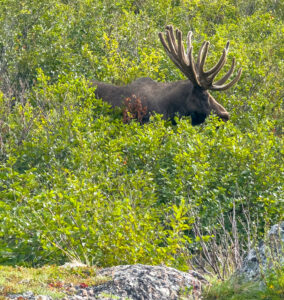
Huge bull moose – photo by alaskatim
We came to our next cache, owned by akgh519, just as the landscape was transitioning to a more alpine terrain. This would have been an uneventful find except for the presence of a huge bull moose. Fortunately, he did nothing more than give us the side-eye before slowly ambling off. Caballo Blanco really dominated the landscape by now and we could see just how much higher we needed to climb.
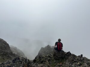
At the summit of Caballo Blanco – photo by alaskatim
Summiting Caballo Blanco brought us the reward of another cache, however, dense cloud cover had moved in during our ascent and spoiled our view from the top. Crossing the ridge to the base of Ruby in the fog was an ethereal experience, especially seeing the guys ahead of me fade in and out of view, yet hearing them well. I’m truly glad I was with this group because a fall would have… well, let’s not think of that.
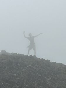
Shrike841 goofing off, unsupervised of course! – photo by Ladybug Kids
alaskatim broke away from the group as we neared the base of Ruby for a few other caches, however, I am sure it was because he was tired of providing the adult supervision. Before you get nervous, though, we still all managed to finish the hike intact!
Ascending Ruby was challenging, enough so that I began to question my wisdom in proceeding ahead rather than breaking away with Tim. We did start seeing some breaks in the clouds, though that mainly reinforced how much higher we had to go. We finally made it despite burning legs and chests. The clouds continued to thin and we started seeing glimpses of Turnagain Arm to the south.
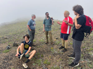
rb127126 is mystified – photo by RSPace
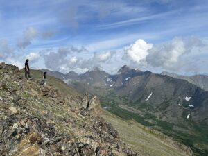
If you guessed the next part of the story involved yet more climbing in the fog, then you are correct! McHugh Peak is a majestic 4,300 foot elevation and we were already tired. Yet, we know that cachers persevere so we eventually made it! By now the sun had almost completely burned off the clouds, treating us to sweeping views of Turnagain Arm, McHugh valley, North and South Suicide Peaks, and our exit, Houdini Hill. Getting to find a FrostG1anT cache at the McHugh summit was simply the bonus.
Shrike841 and rb127126 surveying McHugh valley – photo by RSPace
Having reached our goal of the McHugh summit, we were now faced with the difficult choice of taking a short detour across the ridge to the east and pick up a couple more caches, or start our trek down. You can guess our choice: hint, it was more caches! If by some random chance you thought we might have headed home you should probably turn in your official geocaching card. Really.
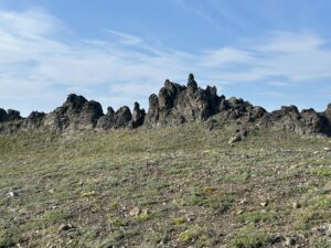
Just some random rocks on a ridge – photo by Ladybug Kids
By now, it was time to head back and we started our decent along Houdini Hill. As with life, there were still some ups and downs to go, but I felt an overall sense of satisfaction whenever I happened to glance back and see where we had been. I won’t lie, getting back to the cars was something of a relief because, wow, I was tired! Too tired and sore to partake in the after-action taco feast. Next time!
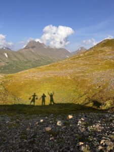
An unconfirmed rumor says this is Shrike841, rb127126, and RSPace, still managing to find time to goof off – photo by rb127126
Lastly, a huge shout-out to Ladybug Kids, who checked out the trailhead two times in as many days: I guarantee he got soaked plowing through the wet foliage the first night. He also helped us with understanding the route and endpoints, so the hike was much smoother due to his efforts.
Channeling BirkenstockReport on our first summit! Also, the trip was 0/10 Birkenstock friendly – photo by rb127126
Total trip stats: 9.25 miles, 4420′ total elevation gain, 12 hour total time. Starting point was Potter Heights Dr and ending at Honey Bear Dr. Because I know you also are wondering: 15 caches were found that day
In July 2026, my younger daughter and I joined my brother and his family for a trip to Thailand to attend a wedding of a Norwegian cousin. The day after the wedding, American and Norwegian family members took a tour of Ao Phang Nga National Park in Phang Nga in the Strait of Malacca between the island of Phuket and the mainland of the Malay peninsula of southern Thailand. The highlight of the tour for me was visiting “Koh Panak Mangrove Hong” Earthcache (GC5TY1K).
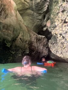
“Koh” means “island” in Thai. A “hong” is a sinkhole that formed in the middle of the limestone island due to the rock being dissolved over time by water, similar to how limestone caves are formed. What makes this hong unique is the bottom is accessible only through a narrow passageway that is filled with water at high tide and becomes navigable as the tide falls. Our tour operator scheduled the tour so we arrived at the island just as the passageway could be swum through, but before the hordes of kayakers arrived. So, with mandatory swim noodles and flashlights (torches) in hand, we jumped off the boat and followed our intrepid guide through the passageway.
We had to be careful not to bump our heads on the sharp rocks and to look up in other places to see the surprising variety of speleothems (draperies and stalactites) growing off the ceiling and upper walls. Just as we entered the hong, the only rain of the day started falling, which was not a problem since we were all already wet from the neck down. Once inside, we enjoyed swimming and walking on the muddy bottom around the mangroves and seeing many mud skipper fish hanging out on the roots and trunks of the trees. We looked up in awe at the circle of sky above us formed by the hong’s vine and tree covered limestone walls.
Once our visit was complete, we headed back through the passage and saw that the tide had fallen enough for a group of kayakers to enter the passageway, but not quite get through, so our timing had been perfect. Photos on the cache page indicate the tide drops far enough for visitors to eventually be able to walk through passageway, leaving kayakers who tarry inside the hong too long high and dry.
With everyone successfully navigating the passageway back to the bay, we set course for “James Bond” island and lunch at a floating village.
When the time comes to remove a cache page from the public-facing geocaching.com website and geocaching application, the “archive” log type under “admin tools” on the website and the “archive” log type in the application is the correct step to take. The local Reviewer or the Cache Owner using the “archive” log type has the effect of removing the cache from cache maps, pocket queries, lists, and other places. The cache page remains visible on the Cache Owner’s “Geocaches Owned” list, but it appears greyed out with the “archived” notation. The cache page may still be logged, but not edited, unless the cache page is locked by a site administrator or the local Reviewer. Only a site administrator at Geocaching HQ or the local Reviewer can “unarchive” the cache page to return it to active status.
Different from the “archive” log is the “disable” log. This log type “disables” the cache page which normally indicates the cache container is unavailable in a field due to the container missing, the location being closed, or for other reasons. The cache page may still logged and edited, and the cache still appears on maps, pocket queries, lists, and other places, but the icon’s appearance is different to signal its disabled status. The Cache Owner and the local Reviewer may “enable” a disabled cache page when the cache is ready to be found.
Cache Owners are encouraged to archive their own cache pages when they are no longer able to perform maintenance on a cache in the field, they move away after removing their container from the field, land manager policy (permits) change, etc. If the Cache Owner only “disables,” the cache page, the cache page remains public-facing and a thirty-day clock starts running which will lead to a follow-up Reviewer Note reminding the Cache Owner to perform the necessary maintenance and “enable” the cache page. If the Reviewer Note is not acted upon, the local Reviewer will eventually archive the cache page, but not before the defunct cache page has continued to be visible for several weeks after the cache itself was no longer viable. This interim period of the cache page being disabled when the Cache Owner knows maintenance will not be performed and the cache page will not be enabled can be skipped by the Cache Owner going directly to the archive step.
Ideally, as Alaska State Parks permit compliance work continues and caches are removed from the field by cachers other than the Cache Owner, an “owner maintenance required,” log should be written to the cache page to notify the Cache Owner that the cache page may be archived. The Cache Owner should then archive the cache page themselves.
By following these logging guidelines, Cache Owners can reduce their local Reviewer’s workload and do their part to keep the playing field clean.
This is an update on compliance with terms of the 2026 Geocaching Permit issued by Alaska State Parks.
August 31, 2026 was the target date established by GeocacheAlaska! Inc. for geocachers to work towards in bringing their cache placements within Alaska State Parks into compliance with terms of the new 2026 permit requirements. Here are notes on progress in meeting compliance goals:
As of August 21, we’ve reached approximately 40% compliant status across all state parks. We’re expecting a dramatic increase in this compliance rate after the August 30th event set in Eklutna valley, with the purpose of removing geocaches associated with the HELP power trail along Eklutna Lake. Please continue your efforts to get ‘owner maintenance’ logs completed on geocaches you own (or where you’ve agreed to act as a proxy for owners who are unable to reach the geocache themselves). See point #2 below for preferred best language to use in logging your owner maintenance visit. Note that compliance with this requirement is being monitored by GeocacheAlaska! Inc.’sAdvocacy Committee using the Geocaching Swiss Army Knife (GSAK) application. After August 31, caches without owner maintenance logs may be disabled by Greatland Reviewer, generally giving one more month to attain compliance with permit conditions. If you receive a “Temporary Disable” note from the local reviewer on your geocache, read the log and the prior reviewer note carefully to see how you can bring your cache into compliance.
Recommended owner maintenance log templates (both physical and online):
Tip: add a photo of the cache logsheet to the online owner maintenance log showing this language to help with confirming compliance! If you act as a proxy, make sure you obtain cache owner agreement ahead of time. Cachers who have already logged an owner maintenance note with “recently found,” “good to go,” and others versions are requested to please edit their logs with the appropriate template to assist the audit team
Annual Owner Maintenance for Alaska State Parks permit number LAS-35694. Cache container inspected and log signed, as required.”
“Annual Owner Maintenance for Alaska State Parks permit number LAS-35694 performed by pre-arranged proxy with CacherX. Cache container inspected and log signed by CacherX on behalf of the Cache Owner.”
Alaska State Parks states it is unable to supply GeocacheAlaska! Inc. with shape files for the more than one hundred state park campgrounds where geocaches are not allowed.
Alaska State Parks replied to our request for state park campground shape files with this statement: “We believe the location of a developed/designated campground should generally be readily identifiable to someone placing or maintaining a cache. A cache owner should not need a GIS layer to determine whether they are placing a cache within an established campground—for example, an area with designated campsites, campground facilities, access roads, signage, etc.” Thus, individual geocachers are responsible for ensuring their geocache placements meet the terms of this statement, and we further recommend that geocachers keep their caches at least 0.1 mile outside of the areas described by Alaska State Parks as ‘readily identifiable’ as an established campground. As always, individual geocachers are responsible for meeting the conditions of use set by land managers.
GeocacheAlaska! Inc. will not be reporting virtual caches or earthcaches as part of the 500-cache limit count to Alaska State Parks. The type of ‘noncompliant use’ of state park lands allowed by permit involves physical geocache containers owned by private individuals which are left on public lands. The no-container aspect of both virtual caches and earthcaches removes them from the count.
As August ends, we geocachers are about to see the onset of fall. This means access to geocaches placed in the wild areas of parks and forests will begin to become more challenging, with snow easily possible at higher elevations by the end of September. Strong efforts by individual geocachers have produced positive results regarding our efforts to bring all geocaches placed on Alaska State Parks into compliance with the new 2026 permit allowing geocaching to occur on state park lands. As of August 21, 40% of all geocaches on all state park lands are deemed compliant with the permit. More than 300 geocaches have been archived, helping us reach towards the permit cap of 500 geocaches total in Alaska State Parks.
The update article contains language we’d like to see used in logging an owner inspection under terms of the permit. Photograph your physical log and include that in the online log! This language allows us to more easily verify owner maintenance efforts as we’re using GSAK (Geocaching Swiss Army Knife) to track status of geocaches on state park lands. Note that we have included a format to document when an owner maintenance visit is performed by proxy (meaning someone whom the cache owner has given permission to for performing the owner maintenance visit). The proxy log helps us keep accountability for how maintenance actions are occurring. Here are those suggested log versions (as also seen in the update article):
“Annual Owner Maintenance for Alaska State Parks permit number LAS-35694. Cache container inspected and log signed, as required.
“Annual Owner Maintenance for Alaska State Parks permit number LAS-35694 performed by pre-arranged proxy with CacherX. Cache container inspected and log signed by CacherX on behalf of the Cache Owner.”
As president, I’m striving to keep a positive mental attitude as I work through my personal emotions generated while working through the issues related to complying with the new permit. There’s been a broad spectrum of negative feelings, and I’m sure you’ve experienced many of them as well. I want to thank our volunteer community reviewer (Greatland Reviewer – Mike Malvick) and our Advocacy Committee member Roy Pace for their suggestions, input, and many many hours of hard work in helping work out the details of implementing the new terms of this permit. Without their work and and feedback, the positive progress we’re tracking would not have been possible.
Again – winter is coming. Please strive to get out and perform cache maintenance visits (and log them online!) so that your geocaches keep their place in Alaska State Parks. And, if necessary, enlist the help of others to reach out and take care of geocaches you’re not able to access right now. We have a suggested proxy log for those visits, and there are quite a few local geocachers eager to help out in achieving successful cache maintenance visits. Don’t hesitate to archive geocaches as necessary, and keep a positive attitude as we strive to become compliant with the permit.

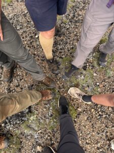
 In July 2026, my younger daughter and I joined my brother and his family for a trip to Thailand to attend a wedding of a Norwegian cousin. The day after the wedding, American and Norwegian family members took a tour of Ao Phang Nga National Park in Phang Nga in the Strait of Malacca between the island of Phuket and the mainland of the Malay peninsula of southern Thailand. The highlight of the tour for me was visiting
 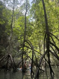 “Koh” means “island” in Thai. A “hong” is a sinkhole that formed in the middle of the limestone island due to the rock being dissolved over time by water, similar to how limestone caves are formed. What makes this hong unique is the bottom is accessible only through a narrow passageway that is filled with water at high tide and becomes navigable as the tide falls. Our tour operator scheduled the tour so we arrived at the island just as the passageway could be swum through, but before the hordes of kayakers arrived. So, with mandatory swim noodles and flashlights (torches) in hand, we jumped off the boat and followed our intrepid guide through the passageway.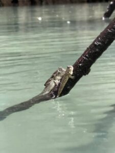
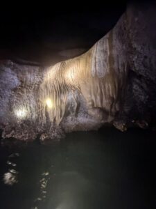
 by Wes Skinner (NorthWes)